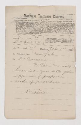
Showing 18185 results

Archival description
McGill University Archives With digital objects
Print preview View:

Map of Egypt

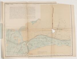
Map of Egypt. Contains an extensive note on the canals in the Wady Tumilat and Tel-Abu Suleiman; surveyed by Lieutenant Colonel Ardagh, Major Spaight and Lieutenant Burton; lithographed at the Intelligence Branch, War Office, under the direction of Major W.R. Fox.

Map of the eastern portion of British North America

Map of the eastern portion of British North America. Includes the text: Including the gulf of St. Lawrence, and part of the New England states. Compiled from the latest surveys and charts by Henry R. Perley for the report of I.D. Andrews to the Honourable Thomas Corwin, Secretary of the Treasury; engraved on stone and printed by D. McLellan.

Map of the sources of Snake River

Map of the sources of Snake River. Includes the text: With its tributaries, together with portions of the headwaters of the Madison and Yellowstone from surveys and observations of the Snake River expedition by Gustavus R. Belcher, chief topographer, and James Stevenson, director.

Map of Pictou Harbour

Map of Pictou Harbour. Includes the text: Surveyed by Captain W.H. Bayfield, assisted by Lieutenants J. Orlebar and G. A. Bedford; London, published according to Act of Parliament a the Hydrographic Office of the Admiralty March 25, 1850.

Results 41 to 50 of 18185