
- CA RBD MSG 433-4
- File
- 1817
Part of Joseph Frobisher Collection
File contains a cartographic survey of the land holdings of the Frobisher estate in Montreal created 7 June 1817.
2 results with digital objects Show results with digital objects
Part of Joseph Frobisher Collection
File contains a cartographic survey of the land holdings of the Frobisher estate in Montreal created 7 June 1817.
Longueuil (Québec)
Québec (Province). Ministère du loisir, de la chasse et de la pêche.
Collection consists of an illustrated manuscript containing a map and brief guidebook to Paris landmarks, created by Nicole Allardet probably during the 1940s or 1950s. The item is inscribed to Vivienne Horne. A folded booklet on heavy grey paper, the guidebook contains twelve panels, ten of which feature a gouache illustrated vignette of a Paris landmark and a short handwritten description in white. The landmarks include the Jardin du Luxembourg, Opera House, Eiffel Tower, the river Seine, the Bois de Vincennes, Notre-Dame de Paris, the Jardin des Tuileries, the Champs-Élysées, Montmartre, and the Luxor Obelisk in the Place de la Concorde. In the centermost two panels is a simple map of Paris showing the landmarks depicted.
Allardet, Nicole
Niagara Escarpment Plan: Recommendations of the Provincial Secretary for Resources Department
Provincial Secretariat for Resource Development
Ontario. Ministry of Environment and Energy
Where Magazine International
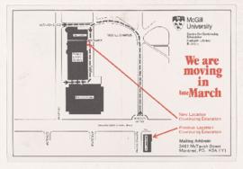
McGill brochures and campus maps
This file contains McGill ephemera with campus maps, including a postcard announcing move of Centre for Continuing Education from Strathcona Hall to the Redpath building (ca. 1982), a booklet containing a walking tour of women pioneers at McGill (Oct 1999), a booklet containing a walking tour of McGill (ca. 1980s), and a campus map (1967).
Kingston (Ont.). Planning Department